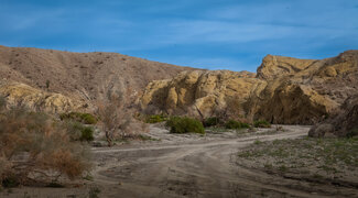
Visitor's View: Coachwhip Canyon
Last updated 2/15/2024 at 11:14am
You might zip right by Coachwhip Canyon while traveling east on Borrego Salton Sea Way, but this short desert wash at the rugged toe of the Santa Rosa Mountains is well worth a little time to explore.
Coachwhip Canyon is one of those special desert places, offering a Mother Lode for spring wildflowers this year, hiking or camping opportunities and a fascinating landscape of geological wonders. Don't leave your camera behind if you plan on a visit.
To reach Coachwhip Canyon, begin mile zero at Christmas Circle in Borrego Springs and go east on Palm Canyon Drive, also known as Highway S-22 and becoming Borrego Salton Sea Way.
The road will jog north past the airport and again turn east at Pegleg Monument. Continue for 15.6 miles and watch for a small park sign at a dirt road to the left, just a few yards before the Arroyo Salado Campground turnoff on the right. The campground is a good place to camp if you have a few days to explore this fascinating area.
Coachwhip Canyon is an extension of Ella Wash that flows south from the highway.
Coachwhip can be navigated safely in a conventional vehicle, but there are areas of soft sand and rocks, so be alert to road conditions.
An even better way to explore Coachwhip is to hike the mile or so into the canyon along the easy route.
The snake-like canyon is likely named after the coachwhip snake, a resident of this arid area, known for its speed. It survives by feeding on small rodents, bird eggs, small birds, other reptiles and insects.
Spring is breeding season for the coachwhip, so keep an eye out for this harmless reptile if you soon visit.
But it's never that simple. The canyon could also be named for a species of rush milkweed also known as coachwhip milkweed that is found in the area.
At the highway, the canyon is wide, but it will narrow and the eroded sandstone formations that are cut by eons of erosion will get taller.
Like an invitation into Wonderland, the winding road into the narrowing canyon is an irresistible draw to explore a unique landscape formed by geological forces that include earthquakes, massive faulting, wind and water erosion.
Along the way there are alcoves ideal for camping. The walls of the canyon offer protection for desert winds in addition to being scenic backdrops for landscape photography.
The long shadows of early morning and evening shadows and the soft glow of a full moon will turn the curdled landscape into a photographer's paradise.
With this year's ample rainfall, Coachwhip Canyon has been filled with the blossoms of many wildflower species. Some are in clusters, but others are single plants hidden like rare gems waiting for your discovery.
In the shadows beyond your camp light, you may see movement of a curious kit fox, or on a morning hike the tracks of a desert bighorn sheep that passed through the area.
There is much to explore in the vast expanse of Anza-Borrego Desert State Park. Visitors can enjoy short hikes around the park's visitor center or spend days wandering in trackless wilderness.
Here's a must-have suggestion for anyone interested in exploring California's largest state park.
Pick up a copy of "Anza-Borrego Desert Region," a comprehensive guidebook that includes a detailed park map, mile-by-mile route descriptions and GPS coordinates for popular destinations.
The book is available at the visitor center or the Anza-Borrego Foundation State Park Store, located in the Borrego Springs Mall.
It's a good thing they publish new editions every few years because you will wear it out as you joyfully explore all the park has to offer.
You can reach the author at Ernie at Packtrain.com.


