New Research on San Andreas Fault
Last updated 6/23/2016 at 2:41pm
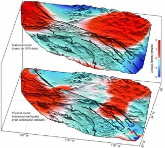
Four huge lobes of the Earth on either side of the San Andreas Fault are sinking, while others are rising, a new analysis of GPS data reveals according to researchers reports, June 20 in the journal Nature Geoscience.
With the help of a new technique, researchers have been able to tease out a vertical motion, which "curiously straddled the San Andreas Fault," study lead author Samuel Howell, a doctoral candidate in ocean and earth science and technology at the University of Hawai'i at Mānoa, said in a statement. This is the first time that scientists have revealed the vertical motion sitting along the San Andreas Fault. "While the San Andreas GPS data has been publicly available for more than a decade, the vertical component of the measurements had largely been ignored in tectonic investigations because of difficulties in interpreting the noisy data," said Howell.
The simple motion makes the ground under the fault, appear to be moving as a slow wave.
Researchers currently rely on tiny GPS arrays placed along the 800-miles of the San Andreas Fault, which runs from the Salton Sea to the Mendocino Coast.
Until now, GPS sensor data has been relied on to determine the horizontal motion of the fault. But the vertical motion of the fault can be affected not only by tectonic motion of the plates, but also by everything from rainfall to the levels of groundwater to local surface geology.
Howell's team found that there were four large hunks of ground about 125 miles wide that were uplifting or subsiding on either side of the fault. The findings matched theoretical models for how the earth around the fault was moving in response to powerful earthquakes, however they don't add much to the seismic risk in the region.
With this new understanding, scientists should be able to create a more detailed understanding of the fault, which could in turn help with estimating the risk of future ruptures.


